Sudan
Satellite imagery reveals scale of destruction caused by army air strikes on Darfur’s markets

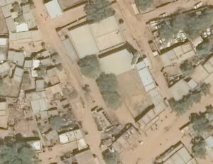
Rhino: Agencies – The Humanitarian Research Laboratory of the Yale School of Public Health has assessed the conflict-induced damage related to airstrikes on markets in Kutum and Kuma in North Darfur from August 9 to October 6, 2024, by analyzing satellite imagery. The damage was likely caused by airstrikes by the Sudanese Armed Forces (SAF).

This report was independently produced by the Humanitarian Research Lab at the Yale School of Public Health with support from the Avaaz Foundation. Dr. Kaveh Khoshnood is the director of the Humanitarian Research Lab at the Yale School of Public Health. The analysis and production of this report was overseen by HRL Executive Director Nathaniel Raymond and Caitlin Howarth. The analysis and production of the report was conducted by the Human Research Lab’s Conflict Analysis Team. Open sources reported that Kutum and Kuma markets were affected by airstrikes by the Sudanese Armed Forces (SAF) on market days on September 30 and October 4.
Potential SAF airstrike activity has reportedly increased as fighting has expanded across Darfur. These airstrikes kill civilians and IDPs, and attacks on markets, especially on specific days, increase the chances of civilian casualties and potentially destroy stores of food and other essential goods.
The Yale HRL report confirms open-source reports of airstrikes on the Friday market in Kuma, North Darfur, by analyzing satellite imagery of damage to buildings from August 9 to October 5, 2024. Opensource sources reported that a Sudanese Armed Forces airstrike killed at least 65 people, including 13 children, and injured about 200. The airstrike, which took place on the usual market day in Kuma, affected the “busy” weekly Friday market on October 4, 2024, and is one of the deadliest airstrikes reported in this conflict.
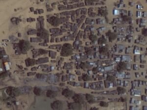
The “kuma” was the civilian administration of the Ziadia tribe, which belongs to the northern Rizeigat ethnic group. Open sources reported that fighting in El Fasher displaced people to Kuma, and Yale HRL has identified temporary structures in the satellite imagery that are consistent with IDP shelters in Kuma.
Yale HRL corroborates open-source reports of airstrikes on the market in Kutum, North Darfur by analyzing satellite imagery collected from September 25 to October 6, 2024. Open sources report that on Monday, September 30, Sudanese Armed Forces airstrikes damaged the Kutum market on market day, as well as residential neighborhoods, killing at least five people, as also determined by Yale HRL. Two hundred thousand people reside in Kutum, and the neighboring Kassab and Fata Borno camps for internally displaced people. Kutum has a population of Rizeigat and non-Arabs, including a large Zaghawa community.

The Famine Early Warning System Network (FEWS NET) has determined that the Kutum and Kuma districts are facing integrated stage emergency conditions, the second highest level of food insecurity. Markets are likely to be densely populated on market days and serve as critical infrastructure. Attacks on markets in these communities, which include internally displaced people, are likely to exacerbate existing food insecurity conditions.
The Yale HR Lab utilizes data fusion methodologies from open-source data analysis and remote sensing data. The Yale HR Lab produced this report by comparing open-source data, including social media, local news reports, multimedia and other verified reports, and remote sensing data, including satellite imagery and thermal sensing data. This analysis involves identifying potential events, geolocating them, and assessing the likelihood of an event occurring through the intersection of open source data and satellite imagery data.
Researchers analyze open-source data from social media, news reports, and other publicly available sources to identify and verify incidents, and analysts assess the credibility and reliability of open-source data based on the reliability of the previous source, and the reliability of other independent sources.